District
Plats of Survey, Baldwin County/Jones County.
Land Districts 6,7, 8, 9, 10, 11, 12, 13.
Georgia's Virtual Vault. See Baldwin County.
Hargrett Library Historical Maps
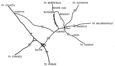
A map of Gray (community) and Jones County
is available upon request. Send e-mail to: jcgchcom@mylink.net Sandra McKinney
(Chamber of Commerce) **Remember to tell them you learned about them on
the Jones County GAGenWeb site!**
1822 map Remember Jones County was laid out in 1807.
1823 map Changes as Bibb County was created in 1822.
1830 maps shows Clinton and Cedar Creek, Walnut Creek and Ocmulgee River
Towns:
Midway, Blountsville, Fortville, Lannington
Waterways:
Ragurs Creek, Allison Creek
1839 map
1863 map Towns: Blountsville, Etheridge, Grab, Tranquilla, Wallace, Poverty Hill, On R.R. line Whitaker, Griswoldville
1874map Towns: Blountsville, Clinton
1883 map Towns: Round Oak, Long Shoals, Cardville,
1885 map
1895 map
1904 map
1910 map
1915 map
1952 map
1970 map
1970 additional map
We are indebted to Ed Jackson for all the work on this marvelous site.
http://www.cviog.uga.edu/Projects/gainfo/
Copyright: Virginia
Crilley 2001
Web Master:Eileen
B. McAdams 2009
| Back to the top | Jones Co Page | GAGenWeb State Page | USGenWeb Page