Indigenous settlement
The lower Ocmulgee supported established Native towns, farmsteads, travel networks, and political communities before and during the period of early European contact.
Telfair County, Georgia GAGenWeb Project
Ichisi, the Glass Site, and the continuing search for Georgia's sixteenth-century trail
In the spring of 1540, Hernando de Soto's Spanish expedition entered the interior of what is now Georgia. The surviving accounts describe an Indigenous province called Ichisi along the Ocmulgee River. For many years, the most widely accepted reconstruction placed that encounter near present-day Macon. Archaeological discoveries in Telfair County have challenged that map.
Rare early-sixteenth-century glass beads, iron objects, and other European materials were recovered within a substantial Indigenous settlement known publicly as the Glass Site. Archaeologist Dennis Blanton has proposed that this community may have been the Ichisi town visited by De Soto around March 30-April 2, 1540. The interpretation is compelling, but it is not universally accepted.
The story matters because it places Telfair County within a major debate about the earliest recorded encounters between Indigenous peoples and Europeans in Georgia's interior. It also reminds us that De Soto's brief appearance was only one moment in a landscape shaped by Native communities for generations before Europeans arrived.

Historical accuracy depends on separating a regional connection from a proven route through a modern town.
The lower Ocmulgee supported established Native towns, farmsteads, travel networks, and political communities before and during the period of early European contact.
The Glass Site contains unusually early Spanish materials consistent with direct contact before 1550. De Soto is a leading explanation, but the identification has not been proved beyond dispute.
The archaeological evidence was found at a protected site along the Ocmulgee River in the Jacksonville area of rural Telfair County. The precise archaeological location is intentionally generalized and is not marked on this public page.
Four principal narratives survive from the De Soto expedition, but they do not provide modern coordinates. Their descriptions of direction, distance, rivers, towns, food supplies, and travel time must be compared with archaeology and geography. The accounts are also European records of Native places whose names were written in several forms.
Historian Charles Hudson reconstructed Ichisi near the Lamar Mounds south of Macon. Blanton's Telfair County discoveries lie roughly 80 to 90 miles southeast of that proposed route. Because early Spanish objects are rare in Georgia's interior, their concentration at a large Native settlement demands serious attention. Researchers continue to evaluate whether the objects represent De Soto's party, another early Spanish intrusion, or exchange through Indigenous networks.
Our research standard: The evidence may redraw the route through Georgia, but the project will not turn a well-supported possibility into a settled fact.
When the Associated Press introduced the archaeological discoveries to a national audience in December 2007, its report carried the dateline Jacksonville, Georgia. Reporter Russ Bynum described archaeologist Dennis Blanton working in a clearing among planted pines in rural Telfair County near the Ocmulgee River.
The archaeological evidence is associated with the Ocmulgee River in the Jacksonville area. That places Jacksonville within the correct general setting of the discovery; however, the protected site's precise location is intentionally withheld, and the evidence does not prove that De Soto entered the boundaries of the later town itself.
The early investigation had recovered five ornate glass beads and two pieces of iron alongside Indigenous pottery. Blanton said the finds strongly supported contact with a sixteenth-century Spanish group, while still speaking cautiously about whether the visitors were De Soto's expedition. Continued excavation and later analysis substantially expanded the evidence and strengthened the case for identifying the community with Ichisi.
This geographically scaled reference map places the Telfair evidence along the lower Ocmulgee in the Jacksonville area without publishing the protected Glass Site's precise location. Modern places are included for orientation, while the proposed expedition lines remain interpretive rather than navigational.
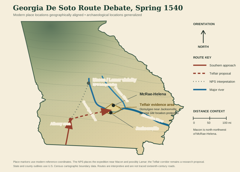
In January 2026, James Madison University reported that Blanton's team had recovered a sixteenth-century Spanish sword pommel and other evidence at a site near Albany. Blanton identifies it as the first proven De Soto encampment outside Florida and connects the area with Capachequi. If the interpretation withstands full scholarly review, it gives the Georgia route a stronger southwestern anchor. It does not, by itself, establish every mile between Capachequi and Telfair County or settle the identification of the Glass Site as Ichisi.
| Stage | What can be mapped | What remains uncertain | Confidence |
|---|---|---|---|
| Anhaica Winter 1539-1540 | The expedition's winter headquarters is securely associated with present-day Tallahassee. | The precise road used when the main force departed northward. | High |
| Capachequi March 1540 | Recent archaeology supports a major contact location in southwestern Georgia along the Chickasawhatchee drainage. | The site's final published interpretation and the exact sequence of nearby camps. | High / developing |
| Between provinces | A northeastward movement toward a major river and the province called Ichisi. | The actual trail, daily camps, stream crossings, and whether Toa can be placed securely. | Low to moderate |
| Ichisi March 30-April 2, 1540 | The narratives describe a principal town across a “Great River,” a relatively peaceful reception, a multi-day stay, and a river crossing. | Whether the Glass Site was that principal town, another community in the province, or a site holding imported Spanish objects. | Strong hypothesis |
| Beyond Ichisi | The army continued toward other Indigenous provinces, including Altamaha and Ocute, before moving toward Cofitachequi. | How those provinces should shift on a modern map if Ichisi is moved from Macon to Telfair County. | Under revision |
| Jacksonville area | The archaeological evidence was found along the Ocmulgee River in the Jacksonville area of rural Telfair County. | The precise protected site is not publicly marked, and the evidence does not establish that De Soto entered the boundaries of the later town. | Known general area |
This video provides additional historical context for the expedition and the continuing effort to reconstruct its path. It is included as a learning resource; the route interpretations and conclusions on this page remain tied to the cited historical and archaeological evidence.
Video hosted on YouTube. If playback is unavailable here, watch it directly on YouTube.
Generations of Indigenous families live, farm, travel, trade, and maintain political relationships along the Ocmulgee and surrounding country.
De Soto lands in Florida with an armed colonial expedition seeking wealth, supplies, labor, and political control.
Expedition accounts describe towns along the Ocmulgee, a river crossing, exchanges with a principal leader, food, guides, and porters.
Other Spanish journeys and missions extended into Georgia. Later documents connect the province and mission of Utinahica with the wider lower Ocmulgee landscape, although its exact location remains unresolved.
Research undertaken in search of Santa Isabel de Utinahica uncovers evidence of much earlier Spanish contact and renews debate about De Soto's trail.
Ichisi was probably a regional political community composed of a principal town and surrounding settlements. The people encountered by the expedition were not waiting to be “discovered.” They possessed governments, agricultural systems, diplomatic relationships, trade routes, religious traditions, and deep knowledge of the river landscape.
The name “Creek” came into common colonial use later. Survivors and descendants of numerous southeastern towns reorganized within the people now known as the Muscogee. The Muscogee (Creek) Nation identifies the broader Ocmulgee landscape as ancestral homeland. The precise political, linguistic, and cultural relationship between Ichisi, Tama or Altamaha, Utinahica, and later communities remains a subject for research and Tribal consultation.
De Soto's entrada was not a peaceful tour. The expedition demanded food, laborers, guides, and submission; took hostages; and used violence or threats. European intrusion was followed by disease, warfare, enslavement, displacement, and severe disruption across the Southeast.
Telfair County was created in 1807, but its human history began thousands of years earlier. Understanding Native towns, trails, river crossings, and later displacement gives essential context to land records, settlement patterns, place names, and community development.
This working bibliography will be expanded with full publication details, page citations, primary expedition narratives, and additional archaeological reports. Exact locations of sensitive sites will not be published.
This is a growing Telfair County GAGenWeb project. We welcome properly identified photographs, old newspaper clippings, maps, citations, family papers, and documented local accounts related to the Ocmulgee River, Indigenous sites, early Spanish contact, and the history of archaeological research in Telfair County.
Please include the source, date, names, location at a safe general level, and permission for use. Do not disturb a site, remove artifacts, enter private property, or send publicly shareable coordinates for a protected location.
Coordinator: Nikki (Rachael) Mincey, Telfair County GAGenWeb Project
Page status: Research in progress; corrections and documented additions are welcome.